About Us
Observing Antarctic Weather from the Ground & Space: The University of Wisconsin-Madison Antarctic Meteorology Program
The History of Antarctic Meteorology Research at the University of Wisconsin-Madison
 The history of Antarctic meteorology at the University of Wisconsin begins in the 1960s, with research activities by Professor Werner Schwerdtfeger (as well as Professor Heinz Lettau). Schwerdtfeger was already a well-known Antarctic researcher before arriving at the University of Wisconsin-Madison (UW-Madison) in 1963, and he continued this work in Madison until his retirement in 1983. Schwerdtfeger’s work utilized the sparse manned observations, and his studies illustrated the need for additional observations throughout the Antarctic.
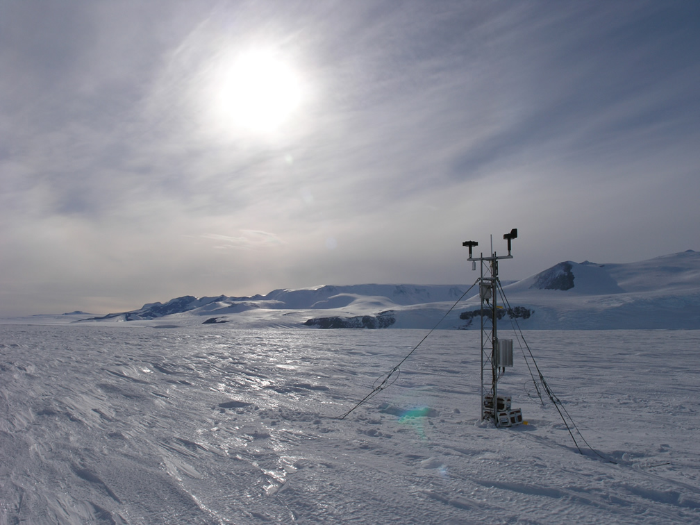
The development of an unmanned automated weather station had been attempted in the United States Antarctic Research Program (later shortened to United States Antarctic Program or USAP) since the International Geophysical Year (IGY). In 1978, Professor Alan Peterson at the Radio Science Laboratory at Stanford University developed the forerunner to the modern Antarctic Automatic Weather Station (AWS). Key stages that led to this initial success were the development of low power integrated circuits and the Data Collection System (DCS) or Argos satellite communication system that allowed for the observational data from the AWS to be recorded on polar orbiting weather satellites and transmitted back to mid-latitude reception stations for analysis.
Antarctic Automatic Weather Station Project
In 1979, Schwerdtfeger introduced the Antarctic to a colleague at UW-Madison, Professor Charles Stearns. Stearns was already very actively developing and setting up instrumentation for meteorological experiments in Wisconsin and other locations. Stearns’ experience and efforts with AWS led to the installation of weather stations around the Antarctic. The data have been used in a variety of research efforts including boundary layer meteorology experiments near the South Pole, Katabatic Wind studies in a variety of locations including Reeves Glacier and the Adelie Coast, the Long Term Ecological Research project along the Antarctic Peninsula, and Barrier wind flow studies along the Transantarctic Mountains and the Antarctic Peninsula, as well as flight forecasting and long term climatology studies of key locations such as Dome C in East Antarctica and historic Byrd Station in West Antarctica.
Today, with funding from the National Science Foundation, Office for Polar Programs, the University of Wisconsin has roughly 63 AWS sites active in Antarctica. That is more than half of all AWS systems currently deployed in the Antarctic. The AWS network fulfills several roles in support of research activities (by the UW-Madison and other research institutions both nationally and internationally), support of non-meteorological research (such as glaciological studies that are the focus of ice core activities in the Antarctic and the study of tabular icebergs), and operational activities such as weather forecasting.
 One of the unique aspects of maintaining the AWS observational network is the necessary fieldwork. A full time job in and of itself, keeping a network of 50 to 70 AWS systems operating, even with international partners, requires a devoted effort of AWS fabrication and repair team members doubling as field personnel. Flying to remote places around the Antarctic and dealing with polar weather conditions makes maintenance a challenge. The success of the AWS network would not be possible without the support of all those who help, directly or indirectly. Thanks go to Ken Borek Air, the 109th New York Air National Guard, PHI Helicopters, Raytheon Polar Services, our international partners in France, Australia, United Kingdom, Japan and China, and the Office of Polar Programs at the National Science Foundation in the USA.
The Antarctic Meteorological Research Center
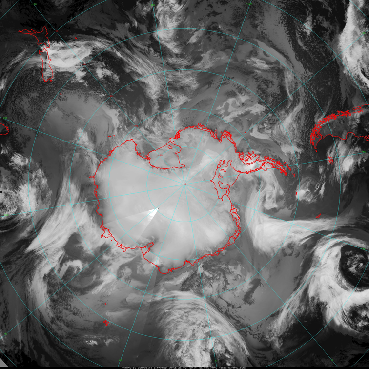
The development of the Antarctic Meteorological Research Center (AMRC) was a marriage between the AWS project and the Man computer Interactive Data Access System (McIDAS) project, also at the UW-Madison. The need for improved Antarctic forecasts, and the potential to develop a mosaic of satellite imagery from both geostationary and polar orbiting satellites over the Antarctic drove the formation of two groups: One that provided weather forecasts in support of research vessels in Antarctic waters, the Antarctic Meteorological Forecasting Center (AMFC), and one that focused on the development of composite satellite imagery and Antarctic meteorological data collection, distribution and archiving, the AMRC. The AMFC provided forecasts for USAP research vessels for several years before the NSF retired this activity and eventually moved it to the United States Naval Warfare System Center (SPAWAR) Office of Polar Programs. While the AMFC no longer exists, the AMRC continues to: create Antarctic satellite composites; conduct scientific research with those composites and other observational datasets; collect, distribute and archive Antarctic data; and promote Antarctic science through educational outreach activities.
The development of Antarctic satellite composite imagery in 1992 revolutionized the view of weather systems around the Antarctic, especially for weather forecasting. Professor Stearns saw the utility in having satellite composites made from both geostationary and polar-orbiting satellites over the Antarctic and adjacent Southern Ocean as a frequently routinely available product. These observations have supported meteorological research and other science investigations for over a decade and a half. They have inspired a variety of applications.
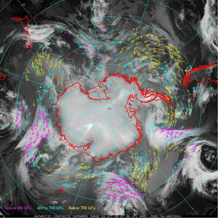
 A recent application of the composite satellite imagery is tests of deriving atmospheric motion vectors. Currently, geostationary and polar-orbiting satellite observations can be used to generate wind vectors based on cloud motions or water vapor target movements over a series of three satellite images. However, the paths of the geostationary and polar orbiting satellites leave a band of high latitudes not covered near the Antarctic/Southern Ocean and near the Arctic. Current efforts are under way to generate atmospheric motion vectors to fill in these “rings” of missing derived wind vectors. With this gap covered, observations helpful to forecasting efforts in these parts of the world will be advanced and offer input to numerical weather prediction models. Parallel studies are being performed to test the ability to track whole cloud/storm systems with these composites.
While Antarctic satellite composites have been available, it was not until 2007 that there was a complete Arctic satellite composite with the coverage, scale and resolution found in its Antarctic cousin. Funded by the Arctic Natural Sciences Program, Office of Polar Programs, National Science Foundation, these composites have already been used in their earliest form to support studies of Arctic pollution. They have been used operationally to support the Polar Study using Aircraft, Remote Sensing, Surface Measurements and Models, of Climate, Chemistry, Aerosols, and Transport (POLARCAT) and Arctic Research of the Composition of the Troposphere from Aircraft and Satellites (ARCTAS) campaigns during the International Polar Year. They will be available for use in the classroom via the Unidata program, Internet Data Distribution (IDD), joining the Antarctic infrared composite, now in its sixteenth year of its availability to the University and educational community.
Improvements to the Antarctic and Arctic satellite composites are always in progress. Creating composites in additional spectral channels, such as water vapor and experimental visible, have been achieved since the development of the initial infrared satellite composite. A “pseudo-color” composite was made, placing clouds and perhaps some sea ice seen in the infrared composite over the NASA Blue Marble background. The resolution of all composites has been improved from the 10-kilometer to the current 5-kilometer nominal resolution. Current efforts underway include expanding the spectral channels to include long wave and short wave infrared and other visible/infrared combinations. Recently, the temporal resolution of the Antarctic composites has been increased to hourly availability, a significant improvement over the previous 3-hourly availability. Improving satellite acquisition, adding recently launched satellites, and better combination techniques of the satellite source data mark the third generation of evolution of the satellite composites.
 For many years, the AMRC has carried out a grass roots collection of Antarctic meteorological datasets, especially focused on the meteorological holdings of the USAP. Today, the AMRC is one of the primary holders of surface and upper air observations from McMurdo and South Pole Stations, along with surface observations from Palmer Station. Additional collections include other USAP observational data sets from other weather station networks, observing stations around McMurdo area, and observations from USAP research vessels operating in the Antarctic.
AMRC data collections also contain Antarctic and adjacent Southern Ocean observation and numerical modeling datasets. These include, but are not limited to: surface manned station weather observations; USAP deep field camp observations; ship and buoy observations; Polar orbiting satellite 1-kilometer resolution local area coverage from the Advanced Very High Resolution Radiometer (AVHRR) instrument on the National Oceanic and Atmospheric Administration (NOAA) satellites; and Global forecast system (GFS) model analyses and forecasts. An extension of the AMRC data collection features copies of observation ledgers used by Lettau and Schwertdfeger in their research work from several decades ago.
Icebergs, Observational Studies, and Educational Outreach
The AMRC and AWS projects have participated in a variety of associated activities. The calving of icebergs in 2000 led to observational studies and routine monitoring of iceberg motions to the present day. While the AMRC tracked the icebergs from space, the AWS program placed AWS units on the larger icebergs in a collaborative effort with glaciologists and seismologists to study both the environment and movement of the icebergs. This effort resulted in improved understanding of the motion of large tabular icebergs from calving.
An example of an AMRC observational meteorological study was the examination of a previous observing system compared to the new surface observing system at South Pole during a year of overlapping observations from 2004 through 2005. Findings noted that the new instrumentation does compare well with the older instrumentation, 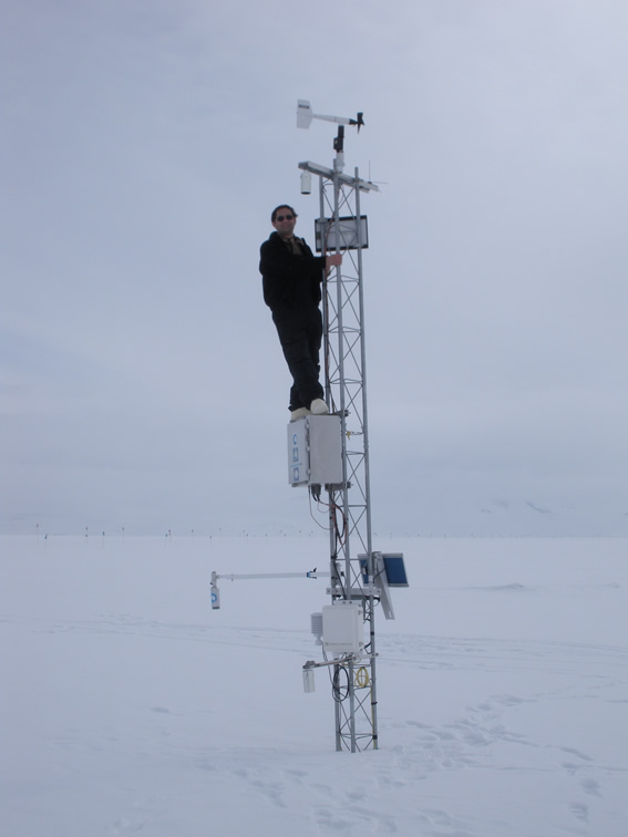 yet reveals some possible inconsistencies in the new dataset as well as guidelines for best usages of the collection. Studies of this caliber document the changes that commonly take place in maintaining a surface-observing program, especially the metadata needed by future researchers.
Educational outreach activities, supported by the National Science Foundation, are an important pillar of the AMRC and AWS efforts. Getting Antarctic information out to the public via responding to e-mail as well as presentations to school children through outreach programs is an important activity that increases awareness of the role that Antarctica plays on the planet. A special project was undertaken at Lodi Area Middle School in Lodi, Wisconsin. Here, students learned to collect, organize and analyze automatic weather station observations and then present the findings. Working with the AWS observations was an activity the students saw as “fun” and a break from the routine of classroom learning, yet gave them practice in critical areas including mathematics, graphic, and data analysis. This activity was very much like the tasks scientists take on when learning, studying and researching: data gathering, data organization and analysis, drawing conclusions, and presenting results. (The author wishes to thank Richard Dworak, Mark Hobson, Linda Keller, and Jonathan Thom for their contribution to this article.)