Skip to Main Content
Space Science & Engineering Center, UW-Madison

AMRC & AWS

Automatic Weather Stations - 2016


[Larger Map] [Historical Station List] [Show UW Stations Only]
Regions:
  • All Regions
  • Adelie Coast
  • Antarctic Peninsula
  • High Polar Plateau
  • Ocean Islands
  • Queen Mary Coast
  • Queen Maud Land
  • Reeves Glacier
  • Ross Ice Shelf
  • Ross Island Vicinity
  • Transantarctic Mountains
  • West Antarctica
Years:
  • 2023
  • 2022
  • 2021
  • 2020
  • 2019
  • 2018
  • 2017
  • 2016
  • 2015
  • 2014
  • 2013
  • 2012
  • 2011
  • 2010
  • 2009
  • 2008
Antarctic Peninsula
Stations (2016):
  • AMIGOS 2/4
  • AMIGOS 6
  • Amsler Island
  • AWS 1
  • AWS 14 (Larsen Ice Shelf)
  • AWS 17
  • AWS 18
  • Bisco Islands
  • Bonaparte Point
  • Butler Island
  • Byers
  • Cierva Cove
  • Dismal Island
  • Filchner
  • Fossil Bluff
  • Gabriel de Castilla
  • Gerlache Strait
  • Greatwall
  • Hugo Island
  • Joinville Is
  • Juan Carlos I
  • Korff Ice Rise
  • Larsen Ice Shelf
  • Limbert
  • Neko Harbor
  • Site 8
  • Sky-Blu

Neko Harbor AWS

Owner: UW AWS UW
Site Code: NKH
Initial Start Date: 2016-01-01
Installed: 2016-01-01
Latitude: -64.8445833333 S
Longitude: -62.5303 W
Elevation: 10 meters


AWS Model: AWSCR1000
ARGOS ID:
2016 Archive (FTP): 3-hourly | 10-minute

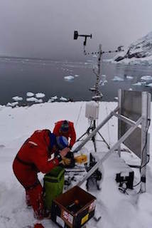
Notes: Neko Harbor AWS is installed as part of a Scripps Research Institute fjord ecology project.


1 Photo
Last updated: 2017-12-18 by SSEC Webmaster NSF USAP SSEC